Ans: Yes, you can if you own the site or work there as a builder and have taken permission from the project owner and the concerned legal authorities, if required!

Aerial View of a Construction Site: Benefits, Uses, Best Practice Tips & All You Need
The aerial view of a construction site is a critical tool when it comes to analyzing the site from above. Without a comprehensive image, key stakeholders involved in a construction project won’t be able to make quality decisions. Professionals need aerial photo-capturing techniques because they require more accurate insights, measurements, and views that aren’t possible from the ground level. So, let’s get into aerial views and their usability in construction in this article.
Table of Contents:
- What is an Aerial View of a Construction Site?
- Why Construction Companies Use Aerial Site Views
- Key Benefits of an Aerial View of a Construction Site
- Applications of Construction Site Aerial Photography
- How Drones Are Transforming Construction Monitoring
- Challenges in the Use of Aerial Technology on Construction Sites
- Best Practices for Construction Site Aerial Photography
- Conclusion
- FAQs
What is an Aerial View of a Construction Site?
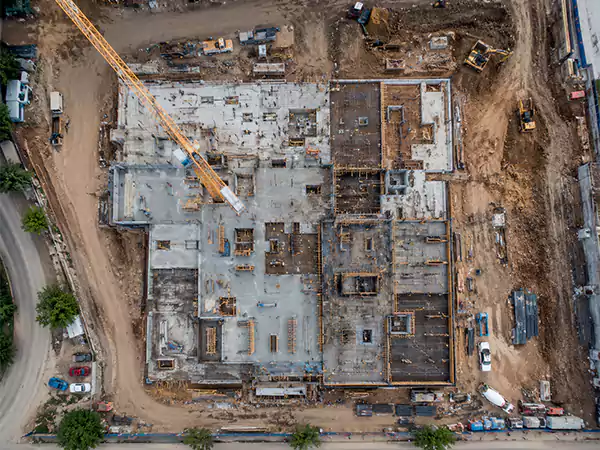
The aerial view of a construction site is a bird’s-eye view taken from a point high above the building. This view can be made possible through technologies such as drones, helicopters, satellites, etc. Aerial photography is a crucial part of construction when it comes to surveying the various stages of site development.
Drones are mostly preferred for this elevated activity, though clients’ preferences are always prioritized. Aerial videography and photography are both very common in all construction types.
Also read: Todd Creek Farms Homeowners Association Lawsuit: Everything Homeowners Need to Know!
Why Construction Companies Use Aerial Site Views
In short, an aerial view of a construction site is used for the following 12 purposes.
- Site evaluation
- Topographic mapping
- Project planning
- Site preparation & coordination
- Construction progress monitoring
- Quality control
- Excavation or landfill-related estimation
- Safety compliance
- Usage in legal dispute
- Environmental impact assessment
- Documentation
- Marketing
These applications are as important in residential construction as in commercial. The table provided below describes, with elaborations, all these points for using a drone view of construction site.
| Reasons | Elaborations |
| Site evaluation | To check the potential of a particular site in detail before purchasing or starting construction |
| Topographic mapping | To learn about the terrain intensively, such as its geographical features and the nature of the surrounding buildings (which is important for the construction of all types of houses and other forms of building) |
| Project planning | To aid the site construction planning process, or to assess the practicality of an existing plan |
| Site preparation & coordination | To better manage the task of site preparation with high-resolution, comprehensive aerial images (large things can be managed better when seen within a single frame, all in one photograph) |
| Construction progress monitoring or construction project progress tracking | To see how well the work is going or if it is lagging behind the schedule, while a project is under construction |
| Quality control | To ensure quality in the construction with ease (the monitoring, as mentioned above, naturally provides the ease of quality check) |
| Excavation or landfill-related estimation | To roughly calculate (or estimate) the magnitude of projections or depressions on a construction site |
| Safety compliance | To reveal potential hazards in the site and its structure that can be eliminated on time, so negligence cannot be used to bring any type of legal action |
| Usage in legal dispute | To potentially plead guilty during legal proceedings in case a legal action is brought, when you are innocent |
| Environmental impact assessment | To learn how much of an impact the construction on the site is going to make on the nearby environment, so that the project can be crafted in a way that is compliant with the law |
| Documentation | To better document the entire project from start to end with ease and full focus on details |
| Marketing | To market the product right from its making so that, by the time it is complete, enough attention and interest will have been attracted (typically commercial projects) |
Key Benefits of an Aerial View of a Construction Site
The aerial view of a construction site has several benefits. These are listed and elaborated in this section. To mention quickly, they include:
- A bird’s eye view
- Comprehensive overview
- Hazard identification
- Quality & supervision
- Better presentation
- Precise measurements
- Less wastage
- Effective promotional materials
Consider the detailed analysis as provided below.
- A bird’s eye view: The project managers can take advantage of the aerial photo or videography, leveraging its inclusive nature.
- Comprehensive overview: Aerial views are comprehensive in nature in a way that you can get all the important details of the site, its landscape, or even the layout of a semi-built structure within a single framework.
- Hazard identification: The high-point construction site aerial photography can also help learn about all the potential hazards that might not be immediately prominent from the ground level. Thus, awareness of them helps take action in time, so future accidents, emergencies, or even wastage of limited resources can be eliminated.
- Quality & supervision: Aerial views are also a great tool for ensuring the quality of work, monitoring progress, and supervising a project under construction in a very effective way. With the recent AI integration in most drones or third-party software, key insights can also be gathered right on the spot for areas of improvement.
- Better presentation: With photographs taken from a high point, the contractor or project manager can make their communication very effective with the client. A comprehensive look at their project and the client will feel better understood and professionally handled. That often boosts the professional image of the site construction manager.
- Precise measurements: Aerial views taken from modern, cutting-edge devices now provide accurate measurements of key dimensions. For example, the professionals can learn how deep a depression is or how high an elevated part of the region can be! Or what is the height of a pre-existing building that needs to be demolished before building anew?
- Less wastage: Precision or accuracy in measurements leads to the least amount of wastage during development.
- Effective promotional materials: Phenomenal pictures shot from the inclusive heights assist in marketing strategies. Buyers get lasting impressions from the stunning visual materials.
Applications of Construction Site Aerial Photography
The aerial view of a construction site comes with significant usability. Thus, it has numerous applications in the field. These are enumerated below with some context for a swift scan.
Note: Aerial visuals of a site typically help in a variety of construction activities such as evaluation, mapping, planning, preparing, monitoring, ensuring quality, calculating, complying, etc.
- To evaluate the site before construction or even purchase.
- To map the features of a piece of land, basically, the topography.
- To plan a project better, basically, so that the most optimal layout and architecture can be crafted.
- To prepare a site before laying the foundation, and coordinate with colleagues and staff effectively.
- To monitor the progress of a product’s construction, also known as aerial construction monitoring.
- To ensure high quality in the development.
- To calculate the dimensions of uneven parts on a piece of land, i.e., the depth of a depression, or its volume, so that the accurate quantity required to fill it up can be known.
- To comply with the safety standards and the law.
- To produce aerial views as evidence in a legal case, along with site details.
- To gauge the impact of the construction on the surrounding environment.
- To document the project while it is being constructed, typically from start to end.
- To create better marketing materials with aerial photographs.
Also Read: How Much is a Water Softener? Consider an In-Depth Analysis from all the Major Perspectives!
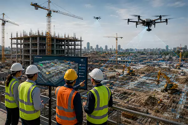
How Drones Are Transforming Construction Monitoring
The use of drone construction photography is really transforming monitoring. It makes the process more streamlined and less inefficient. The major points are improved project visibility, enhanced on-site safety, faster data collection, cost savings across operations, accurate mapping, precise measurements, better communication, and detailed documentation.
- Improved project visibility: See something from the ground level and then from a four-story building. And you will know in no time which option is more inclusive! The same logic applies to the aerial views as well in construction.
- Enhanced safety on site: With drones, workers don’t have to carry out risky manual tasks involved in site monitoring. High-tech, AI-powered flying robots are now all capable of handling the entire process alone, by themselves, with an office operator.
Note: Risky tasks typically involve climbing scaffolding, navigating unstable surfaces, manual inspections, etc.
- Faster data collection: Now, workers or project managers don’t need to wait for days or months to collect reliable site data. Drones, providing an aerial view of a construction site, can provide key insights instantly within minutes.
- Cost savings: Drone surveying is fast and provides high-quality results. Hence, it saves considerable time and cost. These devices can even reach inaccessible spots within seconds. Manual efforts can never achieve this much perfection.
- Accurate mapping: All the details of the topography can be scanned within a short time, with better accuracy and precision. This capability wasn’t possible without drones.
- Precise measurements: Not just mapping, with AI-powered aircraft, now project managers can even get measures of the land and its features accurately. For example, if there is a large depression on-site (due to the existence of a dry pond), now drones can help find its volume in minutes so that the required materials can be calculated with precision.
- Better communication: Previously, the process of inspection was very slow. Formal and decisive talk was only possible once the monitoring data had been gathered through manual inspection or monitoring. But now, the drone-powered construction has changed the entire picture. Things can be modified and discussed right on the spot, in real time.
- Detailed documentation: All the aerial views by the mini-flying aircraft are detailed and comprehensive. Even the minute aspects are included in the photography or videos! Thus, data generated from the construction monitoring can also be used for a detailed documentation process later, saving time and cost once again.
To save time, cost, and scarce resources, all the biggest construction companies in the US use drones for site monitoring.
Challenges in the Use of Aerial Technology on Construction Sites
While implementing the aerial view of a construction site or UAV technology, industry people might face certain challenges. It includes equipment costs, bad weather, lack of skilled human resources, and training!
- Equipment costs: In small-scale construction projects, the initial purchase and set-up expenses can be a big challenge. However, that is not an issue in the long run when savings accumulate, and you start to get a heavy ROI.
- Bad weather: The elements are the next hurdle. You cannot expect drones to work in pouring rain. Water can get into the system and cause a malfunction. But that shouldn’t be a major con, as most construction sites are left off at the time of bad weather. And then workers pick up the suspended work later!
- Lack of human resources: Unmanned Aerial Vehicle (or UAV) technology is pretty new! Construction professionals are still learning a great deal. Thus, another problem in the adoption comes due to the lack of skilled operators and resources.
- Training: Implementing this new technology to streamline construction also means training the existing workers. Without education, they won’t be able to use it to the fullest. However, many can even take it like an investment for which they will get huge returns in the future in terms of time and cost.
Houseura Insight: All the new technologies like AI, robotics in construction, etc., need upskilling and initial investments. But that shouldn’t prevent companies from leveraging their power and boosting productivity. Initial expenses often result in big savings later.
Also Read: MEP in Construction: Meaning, Importance, Common Problems, Future Trends, and More!
Best Practices for Construction Site Aerial Photography
Consider the key insights below for the most optimal aerial view of a construction site. These tips are basically related to two types of photography angles, typically used by professionals, namely, oblique and nadir.
| Oblique Photography | |
| Features | Configurations |
| Horizon placement | At the top of the frame for better orientation |
| Altitude | Best when placed between 30 and 50 m or above the tallest object |
| Waypoints | Best for standardized coverage when used |
| Capture rate | Every 2 seconds at 15 m/s forward speed |
| Nadir Photography | |
| Features | Configurations |
| Camera angle | 90° downward |
| Capture rate | Every 1 second or ≥ 80% forward overlap |
| Ground sample distance (GSD) | Fly at altitude for ~2 cm GSD |
| Side overlap (flat terrain) | 60 – 66% |
| Side overlap (high relief terrain) | Beyond 66% |
| Corridor mapping | Flight lines by 9 m left & right of the center line |
| Flight mission setup | In the middle of the area |
| Battery management | Try to complete all your activities until the battery drops to 80% |
| Ground control points (GCPs) | Record equal or greater than 1 min of RTK data at 1 Hz at each point (mounted on a bipod) |
| Camera Settings (Both Nadir & Oblique) | |
| Lighting | Preference for sunny conditions and shutter speed lower than 1/500 |
| Cloudy/low sun | Slow forward speed (motion blur < ⅓ of GSD) |
All of these configurations and settings will help you get effective construction site inspection results. In case you need some technical assistance, talk to your provider or the product’s user manual.
Conclusion
The aerial view of a construction site helps in various activities before, during, and after construction. Such pictures or videos taken from high above make key processes easy, such as site evaluation, topographic mapping, project planning, etc.
Previously, there was no such capability available to inspect a site at various angles, and manual inspection wasn’t that effective! Now, aerial surveying in construction is really making a big difference.
FAQs
Q: Can I fly a drone over a construction site?
Q: What is considered an aerial view?
Ans: It is a technique in photography where pictures are taken from high above the ground at an elevated point. A camera faces downward and captures the images of the Earth below. The UAV technology seamlessly allows for this capability.
Q: How does an aerial view work?
Ans: When a camera is placed at a far point, it can capture the image of a very wide piece of land. That high inclusivity in photography is something valuable. When this element is needed from a vertical angle, drone photography is used, which provides aerial views.
Sources:
IMAGE INVENTIONS: Why Use Aerial Photography on a Construction Site?
AIR ASPECTS: The Benefits of Aerial Photography in Construction